| Rock Routes at White Ledge (Albany): grouped by Area, sorted by Name |
 |
White Ledge overview |
A White Ledge Short History by Brad White (IMCS)
White Ledge has been known about in North Conway climbing circles for a long time but not fully explored till now. After a failed attempt to find this cliff 30 years ago I pretty much gave up on it till the fall of 2010. Rumor had it that over the years other people had hiked to the base checking it out but most had chosen not to return to climb. Having seen it from a distance many times, I figured that a day spent looking in the woods was in order. Matt Peer offered to join me figuring that a hike was at least good for training. We found the cliff quite easily with the leaves off the trees and were immediately impressed with the climbing potential.
We returned just as snow was about to fly and rappelled the cliff finding one old fixed piton and a few old pin scars (Old Route), one old quarter inch bolt of 1970’s vintage on a run out slab and nothing else. I was amazed that not even a single piece of webbing or rappel ring was found. (While cleaning in the spring of 2012 two other fixed pitons were discovered under the moss and dirt on P2 of Trail of Tears that were removed by finger strength alone.)
Over the Winter and spring of 2011, I set out to contact older climbers such as Ed Webster, Paul Ross, Rick Wilcox, Joe Cote, Steve Larson, Chris Noonan and Mike Hartrich to name a few and asked if they had ever climbed here or knew of anyone who had. All said that they knew of the cliff but had not climbed there personally or knew of anyone else who had. I checked older copies of the North Conway new route books and climbing journals but no one had claimed (that I could find) to have done any climbing here even though we knew that some climbing had been done.
Matt Peer and I made the decision to develop the cliff in the summer of 2011 as a modern traditional climbing area with occasional bolt protection where good gear was not available and a few bolt anchors in useable locations. Deciphering what could have been climbed very boldly and what has not been climbed at all, is very difficult when the first explorers declined to record their adventures for others to follow. I am sure that this is someone’s secret cliff but the climbing is too good to keep it hidden forever.
I am listing most climbs as “First Recorded Ascents” even if they were not completely climbed before as listed. We have arranged the climbs pitches in a logical order by difficultly and location. The cliffs slabby nature allows for a bit of mixing and matching of pitches if you are so inclined and many different combinations of pitches have been done. We cleaned the routes and established fixed protection and rappel anchors where needed.
The cliff can be rappelled down the left or right side with a single seventy meter rope. If you have a 60M or less, you will need to bring a second rope or walk off. You will need to have a full modern rack including the smallest cams and nuts, tri-cams and regular cams to a #3 Camalot sized piece to adequately protect most of the climbs. If special gear is needed it is noted in the pitch descriptions. This noted gear is not always absolutely necessary but using it will keep the climbs reasonably well protected. At times a second set of medium cams or medium sized pieces will be helpful for belays. The climbs mostly follow natural features and protection possibilities avoiding bolt intensive development whenever possible.
The headwall area of overlaps and corners suffer from seepage and a few wet streaks after heavy rains but most of the middle and lower pitches dry fairly quickly. Protection ratings are given for certain pitches that may require more attention. Expect a few Whitehorse slab style run outs but in general the protection (with work) is good. This cliff faces south and is sunny and warm early in the spring and late into the fall. |
White Ledge is located just off the White Ledge Hiking loop trail located in Albany, NH on RT 16, South of Conway. Park in the White Ledge Campground. Use the visitor parking section, just inside the gate on the right. The trail starts at the back right side of the campground, start here.
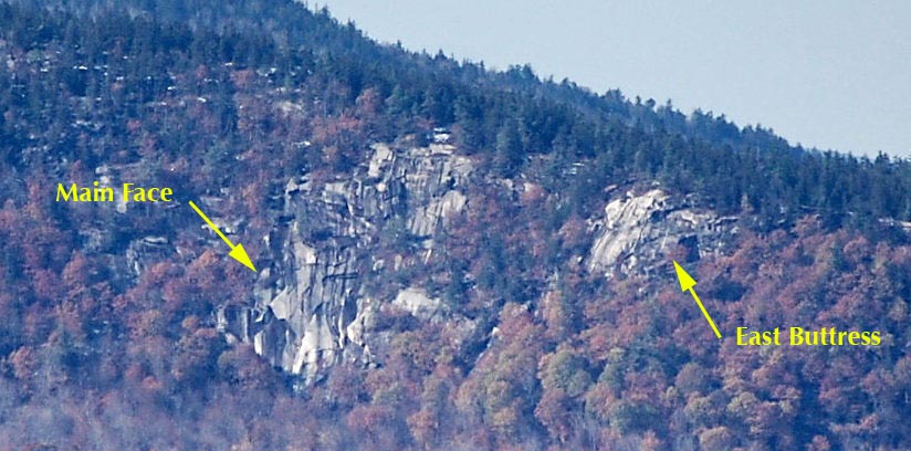
The Main Face:
Walk .3 miles to the loop intersection and turn right. Walk another .3 miles to another signed intersection and turn left onto the loop proper. (Right takes you back to Rt. 16) Walk a little less than a mile up the trail till you come to a flat saddle at the height of land. Continue downhill 5 minutes or so and you will come to an 18” natural granite step in the trail that is a small dry streambed. A faint yellow trail marker is on a large dying tree 15 feet ahead on right. Walk a few feet further and then bushwhack left (Northwest) from the trail slanting slightly right 400 to 500 feet till a house sized boulder with a cool cave underneath can be seen. You can also walk another 100 feet or so on the trail and then follow the next drainage uphill to the boulder. The base of the cliff is directly uphill 300’ from this boulder.
The best way to get thru the talus is to circle around the right side of the boulder. The approach time is about 35 minutes to one hour from the parking lot to the toe of rock at a modest pace with the majority of hiking on the trail.
If you top out on the cliff after your climb, walk back about 400 feet moving (Northwest) slightly downhill/right and you will soon cross the hiking trail. Turn left at the trail and walk uphill for 10 minutes and you will be at the summit view area. Follow the trail south back down to the campground.
The East Buttress:
This area is located high up and right of the Main Face and separated from it by a rubble filled gully and small blocky walls. This crag has a wonderful view and is sunny and warm late into the day. As with its neighbor, White Ledge, previous climbers have explored here but not recorded their climbs. A very strange old quarter inch bolt (circa 1970's?) was found a few feet from a good crack on the left side of the face with no indication of where (or if) the climb went from there.
To get to the bottom of this south facing crag is a logistical problem. If approaching from the bottom follow the directions to White Ledge. When at the house sized boulder head East/right along the terminus of the talus until you are heading uphill to the wooded shoulder. If you head uphill right away you will run into quite a number of small scrubby sometimes overhanging walls and dirty slabs that will block access to the bottom of the face. Hike left, (uphill) on the shoulder and pick a wooded ledge system near the cliffs bottom and traverse in to belay trees at the base. If approaching this way, add an additional half hour and a bit of thrashing to your schedule. The easiest way might be to hike to the top via the loop trail over the summit and rappel down, but this takes a bit of the mountaineering adventure out of it (if you like that sort of thing).
If hiking off from the top head back NW 400' feet or so and you will soon cross the hiking trail. You can turn either way on the loop but it is shorter to head uphill (left) over the summit and south back to the campground. The face is between 150' and 180' high from the wooded belay ledges but can be rappelled with single 60m rope. Rappel from a large Pine at the top, 50' to a small 6” diameter spruce tree in the center of the face, then to the ground.
|
| A graphic topo is available for this area. CLICK HERE |
| East Buttress |
Blister In The Sun |
5.7 |
| East Buttress |
Chasing the Sun |
5.8 |
| East Buttress |
High Voltage |
5.10+ |
| East Buttress |
Men in Bright Lycra |
5.7 |
| East Buttress |
Out of the Forest |
5.7 |
| East Buttress |
Shisha |
5.9 |
| Main Face |
5.7 Link Up |
5.9 |
| Main Face |
Eminent Domain |
5.9 |
| Main Face |
Go West Young Man |
5.7 |
| Main Face |
Illusion of Prosperity |
5.10 |
| Main Face |
Manifest Destiny |
5.8 |
| Main Face |
Old Route |
5.7 |
| Main Face |
The Rusty Bolt (Old School 5.9+ R/X) |
5.9+ R/X |
| Main Face |
Trail Of Tears |
5.9 |
| Main Face |
White Riot |
5.10+ |


